

Butte Valley is located in NE Siskiyou County and is a high desert valley, elevation 4250 ft. surrounded by mountains. The valley enjoys an average of 275 of sunshine annually and the winter snows rarely stay on the valley floor more than a few days. However, during the winter travel season our highways 97 and 161 can become challenging. The Butte Valley Chamber of Commerce provides these pages to assist locals and visitors alike. When weather conditions warrant, we take additional time and effort to travel safely.
FOR COMPLETE ROAD AND WEATHER CONDITIONS/ADVISORIES I5, CA 97, OREGON 140, 66, 199NORTHERN CALIFORNIA AND SOUTHERN OREGON GO TO tripcheck.com
FOR CURRENT AND 7 DAY FORECAST ANYWHERE IN BUTTE VALLEY GO TO National Weather Service Forecast
FOR REGIONAL WEATHER CONDITIONS GO TO Northern California Enhanced Satellite imagery
LOOKING FOR DIRECTIONS TO AREA LOCATIONS OR FAR AWAY DESTINATIONS? Google Map
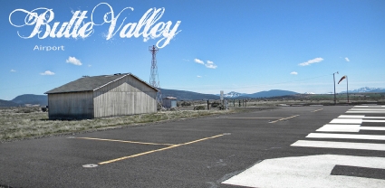
BUTTE VALLEY AIRPORT
Butte Valley Airport is located just 5 miles south of the City of Dorris on Hwy 97. It’s FAA LID No. is A32. The airport is a county-owned, public use airport. Per FAA sources, during 2008, there were some 2200 flight operations at this site. The airport elevation AMSL is 4243 feet, direction is 16/34, Runway length 4300 feet and the surface is asphalt. Butte Valley Airport covers and area of 234 acres.
The airport is unmanned. Aircraft tie downs are available; however, no other services reside at the airport. Runway lights can be activated by keying 5 times on Frequency 122.9.
Siskiyou County manages the airport and can be reached at 530-542-8295.
An aeronautical chart for A32 can be found at skyvector.com/perl/code?id=A32&scale=2
Click on each link for the latest Traffic Cam view
Dorris Cam is located on the north side of Dorris on the west side of SR 97
http://www.oregontravels.com/_roads/sw_CA_US97_Dorris_609.html
For weather info
https://www.accuweather.com/en/us/dorris/96023/weather-forecast/332102
Mt Hebron Cam
is located on the west side of SR 97, north of the summit in Siskiyou County
http://www.oregontravels.com/_roads/sw_CA_US97_MtHebron_612.html
Grass Lake Cam
is located on the west side of SR 97 in Siskiyou County
http://www.oregontravels.com/_roads/sw_CA_US97_GrassLake_610.html